Istituto di Scienza e Tecnologia dell'Inquinamento Luminoso
Light Pollution Science and Technology Institute
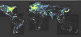
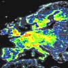
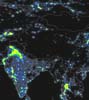
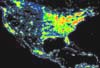
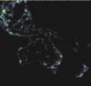
The night sky in the WorldSatellite monitoring of the artificial night sky brightness and the stellar visibility |
|
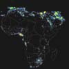
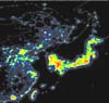
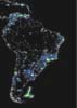
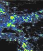
The World Atlas of the Artificial Night Sky Brightness |

Click on the map to make larger
See the section Maps of the artificial night sky brightness for an explanation on what exactly these maps show. See also the Frequently Asked Questions.
For a description of the Atlas and the technique, further details and a statistical analysis, please download the original paper in PDF: Cinzano, P., Falchi, F., Elvidge C.D. 2001, The first world atlas of the artificial night sky brightness, accepted for publication in Monthly Notices of Royal Astronomical Society.
Colours correspond to ratios between the artificial sky brightness and the natural sky brightness of: <0.01 (black), 0.01-0.11 (dark-gray), 0.11-0.33 (blue), 0.33-1 (green), 1-3 (yellow), 3-9 (orange), 9-27 (red), <27 (white).
The figures of this Atlas are copyright of the Royal Astronomical Society.
Reproduction Guidelines for use of the images of this Atlas.
Download a zipped TIFF with a medium-resolution composite map of the entire World (1.7MB zipped; 201MB unzipped). The composite high-resolution maps of individual continents can be downloaded from the relative pages. Be careful because their size is huge.
Open a thumbnail bar in a left frame to browse the Atlas.